POJ-1328 Radar Installation-贪心算法
Description
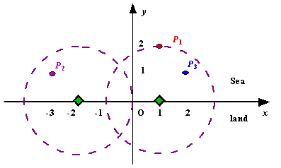
We use Cartesian coordinate system, defining the coasting is the x-axis. The sea side is above x-axis, and the land side below. Given the position of each island in the sea, and given the distance of the coverage of the radar installation, your task is to write a program to find the minimal number of radar installations to cover all the islands. Note that the position of an island is represented by its x-y coordinates.

Figure A Sample Input of Radar Installations
Input
The input is terminated by a line containing pair of zeros
Output
Sample Input
3 2
1 2
-3 1
2 1

1 2
0 2

0 0
Sample Output
Case 1: 2
Case 2: 1
#include<cstdio>
#include<cstring>
#include<cmath>
#include<iostream>
#include<algorithm>
using namespace std;
struct Island
{
	double left;
	double right;
}island[1100];
bool cmp(Island a,Island b)
{
	return a.left<b.left;
}
int main()
{
	int n,d,i,j,t,temp=0;
	double x,y,fuck;
	while(~scanf("%d%d",&n,&d),n+d)
	{
		int m=0;
		temp++;
		for(i=0;i<n;i++)
		{
			scanf("%lf %lf",&x,&y);
			if(y>d||d<0)
			{
				m=1;
			}
			island[i].left=x-(sqrt(d*d-y*y));
			island[i].right=x+(sqrt(d*d-y*y));
		}
		if(m)
		{
			printf("Case %d: -1\n",temp);
			continue;
		}
		sort(island,island+n,cmp);
		t=1;
		fuck=island[0].right;
		for(i=1;i<n;i++)
		{
			if(island[i].right<=fuck)
			{
				fuck=island[i].right;
			}
			else if(island[i].left>fuck)
			{
				t++;
				fuck=island[i].right;
			}
		}
		printf("Case %d: %d\n",temp,t);
	}
	return 0;
}
郑重声明:本站内容如果来自互联网及其他传播媒体,其版权均属原媒体及文章作者所有。转载目的在于传递更多信息及用于网络分享,并不代表本站赞同其观点和对其真实性负责,也不构成任何其他建议。


